Application of GIS in Conservation Mapping
Official Launch Alert!
Regional Centre of Excellence (RCoE) for Biodiversity, Forests, and Seascape Ecosystems Management
Are excited to announce the launch of our online course:
Application of GIS in Conservation Mapping
Date: 11th August 2025
Time: 11:00 AM (GMT+3)
This course supports efforts “Towards the Achievement of Target 3 of the Global Biodiversity Framework.”
Whether you're a conservationist, GIS enthusiast, or environmental planner, this course is designed to equip you with the tools to map, analyse, and protect biodiversity using spatial data.
Register now: https://lnkd.in/dMkYRsAW
Don’t miss it, scan the code in the poster or click the link above to secure your spot!
https://www.linkedin.com/posts/regional-centre-of-excellence-rcoe-for-biodiversity-forests-and-seascape-ecosystems-management_gisforconservation-biodiversitymapping-rcmrd-activity-7354033922902523906-qtH8?utm_source=share&utm_medium=member_desktop&rcm=ACoAAEdibOwBZY1xApLOlVv0URTSaBeULhnpmxk

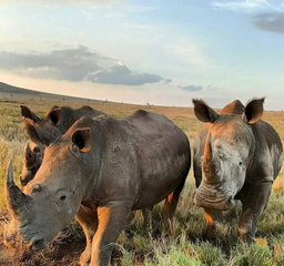
I am a recent graduate from the Wildlife Research and Training Institute, with a passion for conservation and a diverse set of skills honed through hands-on experience.
During my attachment program at Kisite Mpunguti Marine Park and my volunteer work with Reefolution Trust, I have gained invaluable expertise in:
Coral Restoration: Engaging in coral planting, nursery maintenance, and out-planting to rejuvenate marine ecosystems.
Marine Debris Cleanups: Organizing and participating in cleanups to protect our oceans.
Community Engagement: Facilitating group discussions and outreach programs to foster local involvement in conservation efforts.
Data Collection and Entry: Gathering and managing data crucial for research and conservation projects.
Human-Wildlife Conflict Resolution: Developing strategies to mitigate conflicts between humans and wildlife.
My interests are deeply rooted in:
Wildlife Protection: Advocating for and implementing measures to safeguard endangered species.
Environmental Education: Sharing knowledge and raising awareness through my Twitter (X) page.
Habitat Restoration: Participating in projects aimed at restoring damaged ecosystems.
Community Engagement: Collaborating with local communities to develop sustainable conservation strategies.
Policy and Advocacy: Working on policies to support and enhance conservation efforts.
While I currently possess a broad range of skills, I am eager to specialize further and make a significant impact in the conservation community. Being part of the Wild Hub would provide me with the perfect opportunity to refine my expertise and contribute meaningfully to global conservation efforts.
Please sign in or register for FREE
If you are a registered user on WildHub, please sign in